32 Degrees: A Look Ahead to Winter 2024-25
This excerpted article, written by PSIA-AASI Digital Marketing Manager Andy Stein, appears in the Fall 2024 issue of 32 Degrees. You can read the entire article here. Andy is also a degreed meteorologist with more than a decade of forecasting experience, mostly involving mountain meteorology. Here, he shares his winter weather outlook for the 2024-25 season. And don’t forget to tune in to his weekly forecasts on our YouTube channel.
***
What’s up, weather fam? Are you as excited for the upcoming season as I am? Yes, I thought so. If you’re wondering what winter might have in store for us this year, you’ve come to the right place. I love talking about weather almost as much as being out in it.
LA NIÑA RETURNS
We’re heading into another La Niña year. I say another because three out of the last four winters (2020-21, 2021-22, and 2022-23) came with La Niña conditions. In 2023-24, we had moderately strong El Niño conditions, which resulted in a mostly weak showing of winter along the East Coast and the Midwest. A few storms sporadically impacted the Great Lakes region, but many folks east of the Mississippi saw less than normal snowfall for the season. The western United States was hit-and-miss with snow but, compared to the East, the West had a better season – especially the central and southern portions of the mountainous regions. The northern Rockies and Cascades saw warm storms but mostly less than normal snowfall.
Last winter aligned with expectations, although during an El Niño year the East Coast usually sees an active storm track – which equates to more snow. However, temperatures for many areas were too warm to support much snowfall and, in fact, some regions saw record-setting warmth. That meant that a lot of folks battled rain at various times during the season. Not great, but not uncommon!
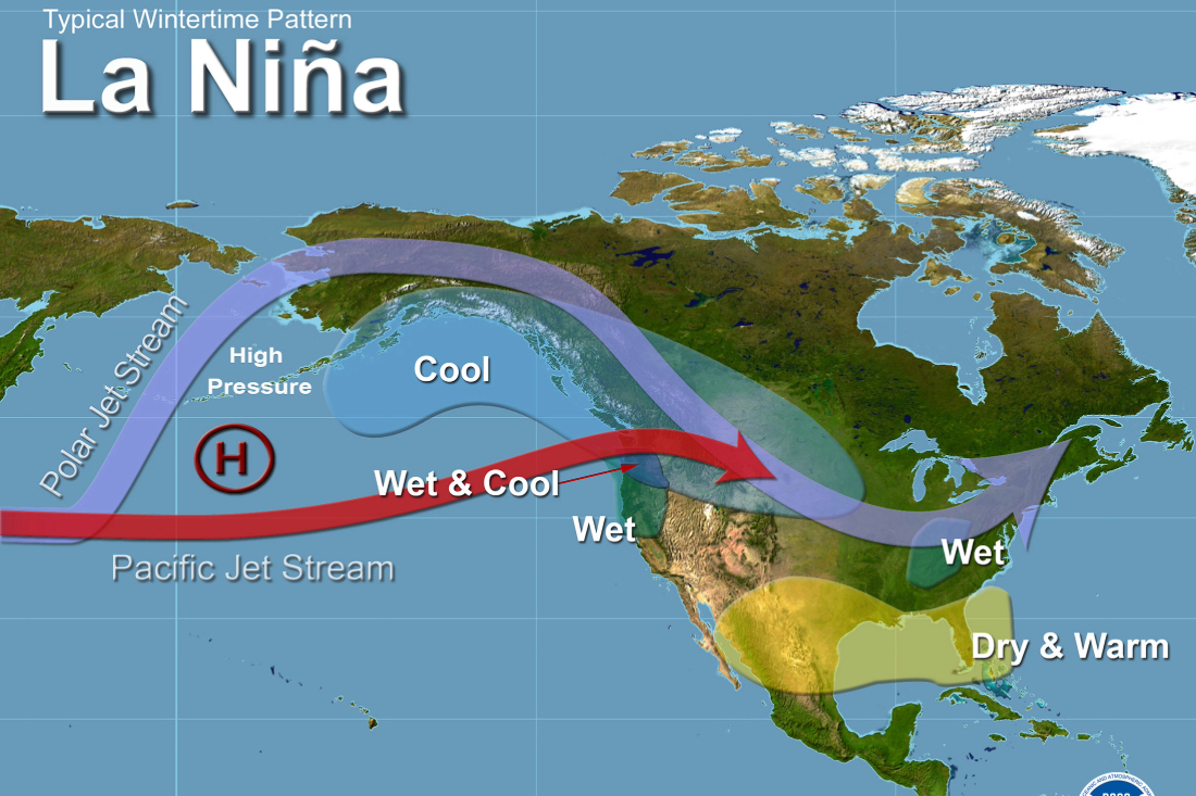
This season, as we head into another La Niña year, let’s review what La Niña is and how it can affect winter across the United States. La Niña is one phase of the El Niño-Southern Oscillation (ENSO), a weather phenomenon in which surface water temperatures in the equatorial region of the Pacific Ocean affect weather patterns worldwide. Warmer than normal sea surface temperatures (SSTs) lead to El Niño conditions, while cooler than normal SSTs lead to La Niña conditions. Average SSTs produce ENSO-Neutral conditions. Some regions of the world experience a more direct impact while others experience less of an impact, depending on the prevailing phase.
When you boil it down, a La Niña phase can cause the jet stream to move north along the Canadian/U.S. border, unleashing cold air and an active storm track in that area. This means generally warmer winter conditions occur farther south. A lot of teleconnections, or weather affecting other weather, occur to make this possible.
The impacts on winter weather nationwide can vary, depending on the intensity and duration of the La Niña event, but some general patterns can be observed. Here’s a quick snapshot as it relates to PSIA-AASI regions:
- Pacific Northwest (Northwest): La Niña typically brings cooler and wetter conditions to this region, leading to increased snowfall in the mountains. This can be beneficial for ski and ride areas in Washington, Oregon, and northern California.
- Northern Plains and Midwest (Northern Rocky Mountain and Northern Intermountain): These areas often experience colder-than-average temperatures and increased La Niña can lead to more frequent cold air outbreaks from Canada, resulting in frigid temperatures and heavy snowfalls.
- Southwest and Southern Plains (Western, Intermountain, and Rocky Mountain): La Niña usually causes drier and warmer conditions in these regions. This can lead to reduced snowfall and a higher risk of drought conditions.
- Southeast (southern Eastern): The Southeast typically sees warmer and drier conditions during a La Niña winter. This can reduce the likelihood of severe weather events like ice storms but can also contribute to drought conditions.
- Northeast (northern Eastern): The impacts in the Northeast can vary, but La Niña often brings milder and wetter conditions to areas from Pennsylvania to Maine. Snowfall can be below average, especially in coastal areas.
- Great Lakes (Central and Eastern): This region can experience increased lake-effect snowfall due to colder air passing over the relatively warmer waters of the Great Lakes. From Michigan to Ohio to western New York, increased lake-effect chances could spell good news for snow lovers.
***
Check out the first episode of “The Inside Edge,” as Andy shares next week’s forecast for PSIA-AASI National Team Training in Colorado.

